Earthquake Insurance, is it worth it?

Here’s an interesting article out of Alaska discussing whether earthquake insurance is actually worth it.

I wasn’t certain how the underwriting worked and it appears that most deductibles are a percentage of the value of your home and they only pay out for large scale disasters instead of minor earthquake
damage.

This information really makes you appreciate FEMA cascadia earthquakeand their role in getting communities back on their feet after a natural disaster.

As always, consult with your insurance agent for more information.

Earthquake Insurance Article

Concerns About Recent Cascadia Earthquake Blog Posts

cascadia subuction zoneI recently stumbled upon a dooms day blog post that addresses the imminent risk of a large-scale earthquake & tsunami within the Cascadia subduction zone region. In fact, this post recently received some coverage on Portland’s KGW.

I absolutely agree there is an imminent risk of a significant earthquake & tsunami – but that’s about all I agree with in the blog post.

Part of the post indicates that this blogger is predicting a wall of water that will annihilate everything west of I-5 attributing this statement to a FEMA representative printed in a recent magazine article.

The original FEMA quote printed in The New Yorker, July 20, 2015 by Kathryn Schulz: “Kenneth Murphy, who directs FEMA’s Region X, the division responsible for Oregon, Washington, Idaho, and Alaska, says, “Our operating assumption is that everything west of Interstate 5 will be toast.” The New Yorker, July 20, 2015 (http://bit.ly/1Sj4Noz)

Aside from their claims, in my opinion they are taking a quote from a FEMA representative out of context and failing to include Kathryn Schulz’s (the author of the original The New Yorker article) follow-up clarifying what the FEMA person quoted in her original article really meant by his statement.

Here’s Kathryn Schulz follow-up in a response printed in The New Yorker two weeks later: “…“toast” is not what you would call a precise description, so let me be more specific. What Murphy did not mean is that everyone west of I-5 will be injured or killed; FEMA’s casualty figures, while horrifying, amount to under one-half of one per cent of the population of the region.” The New Yorker, July 28, 2015 (http://bit.ly/1GZjwhU)

I agree that west of I-5 will be severely affected; however, it’s unfair and inaccurate to say everything west of I-5 will be gone. But this blog won’t stop beating its drum with that hyperbolic quote that was obviously taken out of context.

The news station continued to look into the blogger’s recent allegations about a buoy showing signs of distress alleging it’s a predictor of severe seismic activity and the station refuted their data points with experts in the field countering the blogger’s claims. (KGW: http://www.kgw.com/news/local/geologist-debunks-nw-earthquake-article/18328115)

The end. Or so we thought.

I got half way through another Cascadia earthquake blog post before I had to stop reading. It made me mad. I feel that what they are doing is essentially running into a crowded theater and screaming “FIRE!!!!”  They repeated several times that they are not trying to incite fear… but in my opinion… I think they are.

Yes, we are overdue for a possible 9.0. Rather than being Chicken Little posting about a buoy dropping up and down (which who knows if it’s even a relevant data point and or a predictor… I will leave that to actual experts) let’s talk about how to prepare for the catastrophic event instead. Such as getting one gallon of water per person per day for up two weeks and for some areas along the coastline even longer, plus don’t forget about food & water for your pets. Or, knowing how to shut off your natural gas connected to your home. Or, speak with your schools so you know how they are preparing for an earthquake….Instead of carrying on about an alleged 50 foot wall of water that will reach I-5!

tidal wave.jpg


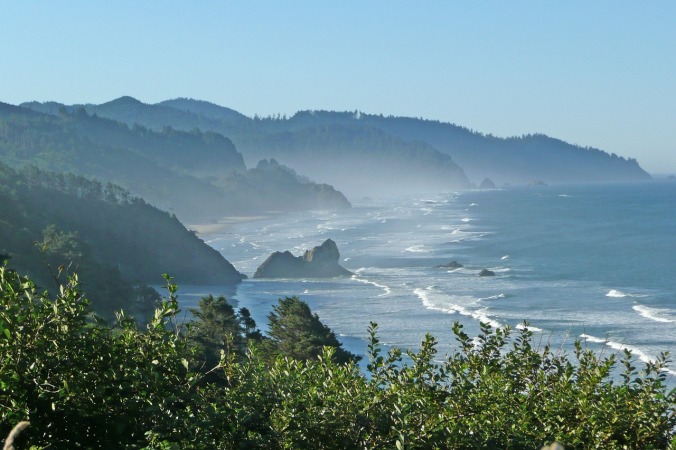
This fear-mongering wall of water that scales past the Cascade Range really doesn’t compute. I am wondering how often he or she has driven Highways 42, 38, and 126 (I know I have driven those roads hundreds if not a thousand or more times in my lifetime traveling back and forth from I-5 to the coast) – the topography of the hills protecting I-5 is impressive more so than anything close to a shoreline that would be vulnerable to severe waves.

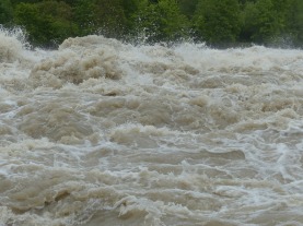
I also want to know if this blogger watched the videos of the tsunami hitting Japan or the deadly tsunami that devastated many countries throughout the Indian Ocean. Many waves were large and powerful beyond measure and it cost many lives… but it wasn’t in biblical proportions scaling mountains and large hills – the waves still had to contend with the topography in its path. Even Chile had a 9.0 earthquake… still no colossal wall of water encroaching on their even grander mountain range.

Quote from CREW Cascadia Subduction Scenario 2013: “The height of the wave and how far inland it travels will vary with location: In places along Cascadia’s coast, the tsunami may be as high as 30–40 feet (9–12 m). Much depends on the local topographythe lay of the land—both underwater and along the shore. In general, the inundation will be greater where the land is low or the topography focuses the waves, such as at bays and river mouths. Other key factors are subsidence and tides: When the fault ruptures, the land in many coastal areas will drop in elevation, increasing the run-up of the subsequent tsunami; and if the quake occurs during high tide, the tsunami will travel farther inland than it would at low tide.”
http://crew.org/sites/default/files/cascadia_subduction_scenario_2013.pdf

My personal opinion, this blogger has watched Deep Impact too many times with Tea Leoni and Morgan Freeman and didn’t pick up the reports AFTER The New Yorker came out to understand how statements were clarified about FEMA (in all likelihood, this will cue the conspiracy theorists).

All I can say is plan and prepare for an earthquake. But please do not panic after reading unsubstantiated dooms day scenarios.

Instead read reports from FEMA, CREW, geologists (Oregon State University has produced some nice content) and other government agencies who hire experts in this field.

Please note: I often use Coos Bay in my examples since I am from there and my family has lived there for several generations (and still does). I know the land and I care about the area and its people.

Tsunami Videos:

A compelling video from the tsunami that hit Thailand. The video shows the calm before the waves approach (go to 56 seconds in to see early signs of the tsunami). Warning the video is graphic as you see people being swept away by the waves.

https://www.youtube.com/watch?v=PW39qbfamFY

A video from the 2011 Japanese Tsunami with footage taken from a helicopter recording the devastation sweeping across the land.

https://www.youtube.com/watch?v=3xKMFzKOIfQ

Another video from the 2011 Japanese earthquake. Around 5:50 minutes you can see a large wave sadly take down a two story building that was close to the shoreline.

https://www.youtube.com/watch?v=IAa8BmuPqh8

A video taken from a roof top as tsunami waves head at them from the shore.

https://www.youtube.com/watch?v=V2taJExhV6g


Before Kathryn Schulz there was Dr. Doom

I have been obsessed with the Cascadia subduction zone for close to a decade now.

I have read countless articles and reports so I can understand the impact this potential devastation may have on my family here in Portland and also my family residing in Coos Bay.

During my research I was always fascinated with Dr. Robert Yeats, professor emeritus of geology at Oregon State University. I recall hearing of his earthquake “nonsense” in the 1990’s. My parents dismissed “Dr. Doom” as rubbish; however, my late grandmother swore that Coos Bay had an earthquake when she was growing up. She spent a lifetime within a two block radius in Coos Bay and she showed me the sidewalk crack (that’s still there BTW) that allegedly appeared after a tremor during her upbringing. It was a bit of lore in my family, however, in 1991 I was in Albany with my grandparents and while on the phone with my mother I hear “The house is swaying!  We are having an earthquake!”  And they did. It was a magnitude 6.6 on July 12, 1991 off the coast of Coos Bay. Everyone (but Dr. Doom) was stunned.

Perhaps Grandma was right.

Deep down, I knew Dr. Doom was on to something.

Fast forward, a few decades and along comes writer Kathryn Schulz. Bravo, Ms. Schulz. You have the attention of the Pacific Northwest and I am hopeful your article will save lives in the long-run.

Dr. Doom never had the audience and now the message is being heard loud and clear.

Thank you – many members of my family are finally listening… I can’t thank you enough.

I am hopeful your message will save many lives throughout the northwest.

PNW Geologists Learn From Other Earthquakes


I would like to applaud geologists for always looking to improve our reporting and forecasting for a 9.0 earthquake.

One thing to note, the state of Oregon re-forecast their tsunami maps after the Japanese earthquake. I assume they took into account how the water flowed in Japan and compared it to the topography along our coastline. For instance, before 2008 the map essentially said the people of Coos Bay would be affected along the beaches (which are a distance from the actual town) and the bay would possibly have a surge similar to the 11-foot tides in the winter months (with 11-foot tides in Coos Bay, the water will reach Highway 101 slightly but not much).

After 2011, the Japanese earthquake showed a more aggressive tsunami and US geologists realized this could happen along our coastline. So they reforecast. Now, a tsunami in Coos Bay can reach all the way out into Libby through the sloughs that feed from the bay. It seems crazy… I would have to drive 15 minutes to get to a beach from the area yet a tsunami will wind its way through various sloughs, tributaries and marshes overflowing into parts of some secluded inland areas. Following the geologist’s logic and looking at the land and understanding the area (my grandparents owned the large ranch in the Libby area where the tsunami inundation zone essentially “ends”) – it makes absolute sense. It’s marshy most of the year even during the summer months. This is conjecture on my part, but the land likely dropped from the 1700 earthquake making it a marsh similar to some parts of Anchorage after 1964. The terrain is similar in texture.

The same goes for a tsunami that might reach Coos Bay’s Blossom Gulch elementary school – which was illustrated in the state’s re-forecast after the Japanese quake. Again, it seems outlandish since you can’t even see water from the grade school but I appreciate the geologists taking into account what happened in Japan and forecasting how that would look along areas such as Coos Bay.  If you live there and understand the lay of the land – it’s logical and makes sense.  I assume it’s the same for other coastal communities.

Thank you to the many subject matter experts and researchers who are working to save lives.

Albany, OR Elementary School Receives Seismic Upgrade Grant

This is a great story where this elementary school received a grant from the State of Oregon. I would love to see more schools receiving these grants so we can keep our kids safe.

Heiwa elementary school %u5E73%u548C%u5C0F%u5B...

Heiwa elementary school %u5E73%u548C%u5C0F%u5B66%u6821 _18 (Photo credit: Wikipedia)

Source:

http://www.albanytribune.com/22042013-albany-school-celebrates-earthquake-awareness-and-state-funded-seismic-upgrades%E2%80%8F/

An Interesting History of the Richter Scale

Here is an interesting history on the Earthquake Early Warning system and the history of the Richter Scale.

Earthquake Richter Scale

Earthquake Richter Scale (Photo credit: Wikipedia)

Source:

http://www.accuweather.com/en/weather-news/history-of-the-san-francisco-e/10658668

Water Heaters: When the Earth Shakes it’s a 600 lb Missile Sitting in Your Garage

Water heater sm

Water heater sm (Photo credit: Wikipedia)

This may sound dramatic which I am at times (just ask my husband about my infamous hyperbole over the years) but we are all sitting on a potential 600 pound “Missile” in our homes. A full size water heater can be extremely dangerous if it’s not anchored when a megathrust earthquake hits.

In fact, according to the State of Oregon Building Codes Division: “The water heater seismic strapping requirements and applicableseismic zones have changed with the adoption of the new codes. Now all water heaters under the 2005 Oregon Plumbing Specialty Code statewide must be strapped. Water heaters installed in buildings within the scope of the 2005 Oregon Residential Specialty Code are required to be strapped in all counties in the state except the following: Wasco, Jefferson, Deschutes, Crook, Sherman, Wheeler, Gilliam, Marrow, Grant, Harney, Umatilla, Union, Baker, Malheur and Wallowa.”

Sample Product (this is not an endorsement, I just pulled the top ranking site that popped up on Google):

http://reviews.homedepot.com/1999/100067210/10-3-in-w-x-13-2-in-d-x-2-in-h-galvanized-steel-water-heater-earthquake-restraining-straps-reviews/reviews.htm

I urge everyone to anchor their water heaters before the big one hits, however, I have to add this story that I happen to find very interesting, ironic, sad, whatever… you decide.  We had our water heater replaced and I was informed by the plumber that I need to anchor it down. Not a problem. I went to… now I dislike using store names but I am going to do it this once since I know this large company (like the company I work for) has a listening tool and Google Alerts set to notify their Marketing team back at their headquarters when their brand is referenced online and I want them to see their “logic” at work. OK, so I went to Lowes in Tigard and I asked for an earthquake restraining strap. The clerk on the West side of Portland told me that they don’t have any in this particular store. I was puzzled. She then proceeded to tell me that earthquake straps are available on the East side of the Willamettte River. Huh? I countered that the subduction zone is off the Oregon coast and last time I checked the Pacific is to the west of the Willamette. In fact, the west side of Portland is probably a bit more vulnerable due to the additional proximity to the fault. The clerk nodded and agreed but then she said “try explaining this to our distribution center in North Carolina. In their mind the only thing threatening our area in Mt. Saint Helens.” Really?!? That’s just so…. 1980. So Lowes Companies, Inc. (I am really trying to hit their alerts now) will you please advise your distribution center that seismic straps need to be distributed to ALL of your Portland stores?!?

And, since Home Depot being another large corporation has alerts set up for their competitors (I know this because our company does this) as well, Hi Home Depot, can you please check to ensure that all of your Oregon & Washington stores carry this strap vs. only having it in one store for a silly reason like Lowes… Thanks.

Reference Link:

Click to access Int100.pdf

Chicken Little: The Ground Will Rumble

Marshfield, Oregon (now Coos Bay) circa 1920

Marshfield, Oregon (now Coos Bay) circa 1920 (Photo credit: Wikipedia)

So, most of my family is from Coos County and boy do they find me annoying. I swear I can start a conversation about how so and so’s son is doing on Varsity basketball and quickly steer the conversation to “Did you know the Tsunami wave will reach all the way to Mingus Park and Blossom Gulch?” I know they get off the phone with me, shake their head, and say “she is at it again.” I can’t help it. This earthquake is looming in the distance and no one has a clue when it will strike. This scares me to death.

I have so many family members down in Coos Bay, let alone worrying about my own kids here in Portland, and I feel this topic is worth discussing. I especially find it disturbing that scientists are saying that the quakes that are occurring offshore in the 5.0-6.0 range are a sign of a megathrust quake in the future — where it might be sooner rather than later. I used to think that these small quakes were a good thing because it is releasing energy by taking pressure off of the fault. Not so according to one study issued by the State of Oregon. That’s unfortunately a myth.

So, I continue to plague my family gatherings with, “so do you have a gallon of water per person, per day for over a week…. and how are you with supplies.” (Cue their eye roll) I only do this because I care so deeply about their safety and I need to focus on my own family and I want the peace of mind knowing that my family and friends are safe.

My advice to all in the Northwest. Prepare. Prepare. Prepare. (a gallon of water, per person, per day for over a week… and don’t forget about your pets, they need water too)

Don’t forget to join us on Facebook (Facebook.com/cascadiaearthquake) and Twitter @CascadiaQuake

A Prediction of 10,000 deaths in the Northwest

I read a study recently discussed on KGW which stated scientists estimate 10,000 people in the Northwest will perish from this megaquake…. this gives me chills. I’m not an overly religious person but I actually catch myself saying a little prayer that my children are not among the casualties. I really, really pray they always remain safe and this earthquake doesn’t occur in their (very long) lifetime.

Unfortunately, I can see this large body count happening after growing up along the coast. The news of the earthquake is a slap in the face and many live in denial. I feel there was almost a false sense of security that “we live God’s country” – we don’t have tornadoes (BTW, I read that one did touchdown in Coos County about 30 plus years ago), no hurricanes (OK, we will not count the Columbus Day storm, where winds at Cape Blanco were well over 145 mph), no black widow spiders (we have the Hobo Spider and they are nasty little suckers), but all in all…. it’s a pretty tame environment or at least so I thought.

Many residents may think that they can muscle through this event, which they may and I hope they do, but without knowing where is safe and where landslides

English: Damage from the Columbus Day Storm of...

English: Damage from the Columbus Day Storm of 1962 (Photo credit: Wikipedia)

may occur, how can you truly be safe?

I implore anyone living along the coasts of Washington and Oregon… know the path of a tsunami whether it’s from a local earthquake or a distant one. (The paths may vary depending on the location of the seismic activity) It will surprise you.

Have a plan and execute it flawlessly.

Evacuation Maps:

Oregon

http://www.oregongeology.com/sub/earthquakes/coastal/Tsubrochures.htm

Washington

Click to access ger_tsunami_inundation_maps.pdf

KGW Article:

http://www.kgw.com/home/Report-makes-chilling-forecast-on-NW-quake-198444741.html

Don’t forget to join us on Facebook (Facebook.com/cascadiaearthquake) and Twitter @CascadiaQuake